
Many regions of the U.S. are experiencing heavier rain events that drop more water in shorter periods of time, and these trends are projected to strengthen over the coming decades. These events may overwhelm local stormwater infrastructure and cause problems for wastewater systems, in part because much of this infrastructure was designed using precipitation data from several decades ago when weather patterns were drier and storms were generally less intense. Aging and under-maintained infrastructure (a problem unto itself) is also less able to handle these heavy rain events, an issue highlighted in the Fourth National Climate Assessment. The implications of these changing precipitation patterns include not only more flooding and service disruptions and greater potential for infrastructure failure, but also changing operations and maintenance (O&M) needs, increased regulatory risks, and rising capital and operating costs.
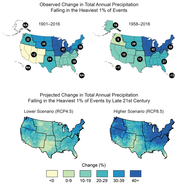
Observed and Projected Change in Heavy Precipitation (from the Fourth National Climate Assessment)
How can a small stormwater or wastewater system cope with these changing conditions on top of their existing infrastructure challenges? How can managers start to adjust decisions, practices, and designs in order to accommodate future conditions? How can all of this be done with limited budgets and staff?
A fair number of financial and technical resources exist to help managers mitigate flooding at wastewater treatment facilities or pump stations. These can be particularly helpful for improving the utility’s ability to maintain operations during an event. Addressing other issues, such as increased inflow and infiltration during heavy rains or making sizing and capacity decisions (for pipes, lagoons, culverts, etc.), can be more complicated, especially when they cannot be based on existing precipitation data and expected population growth alone.
One important factor that feeds into many of these decisions is precipitation–whether it is on an annual, daily, or hourly basis. Many stormwater infrastructure design decisions are already based on the amount of precipitation that may fall within a chosen time period, meaning that a culvert, lagoon, or other facility needs to be able to withstand or capture a certain amount of water as directed by stormwater design guidelines or regulations followed by the utility or community. For example, many places require infrastructure to handle one inch of rain within a 24-hour period. For more important pieces of infrastructure, managers may choose a more conservative (risk-averse) rainfall capture target that aims to handle less frequent but more severe events. Wastewater systems may also need to consider the impacts of rainfall on infrastructure design, particularly for storage lagoons or pump stations that may experience increased loads during storms.
To date, most of these design and management decisions have been based on historical rainfall data–which is a problem in places that are experiencing heavier rain events more frequently than in past decades. These trends are expected to continue and possibly worsen in the future due to climate change (warmer air holds more water vapor). Making decisions so that infrastructure will accommodate future events for which there is little to know information or guidance is daunting even for experienced managers. Fortunately, there are a growing number of resources available to address this need, including data, planning and decision tools, webinars, technical assistance, and funding.
Data that can help managers make improved decisions include updated historical precipitation data (to reflect more recent trends) and projected precipitation. The NOAA Atlas 14 source of precipitation frequency data, used by nearly all communities to set infrastructure design standards, is in the process of being updated to reflect more recent data; the status of updates for each region in the U.S. can be reviewed on this website. Recognizing that historic data no longer meets all of the needs for decision-makers, NOAA will be preparing a new product called Atlas 15 that provides future intensity-duration-frequency estimates (IDFs) with more nuanced information for managers. More information on how Atlas 14 is being updated and what Atlas 15 will look like can be found in this announcement.
A similar tool to the forthcoming Atlas 15 product is the MARISA Mid-Atlantic IDF curve tool that was developed for the Chesapeake Bay plus all of Virginia. This interactive online map and tool generates IDF curves that can be “easily integrated and used to plan, design, and build infrastructure assets to be more resilient to climate change.” Users can view projected IDF curves for different storm return intervals (e.g. 100-year or 2-year) as well as the change factors for a location, which indicate how much more or less rain may fall for the selected storm return interval in future decades compared to the values from NOAA Atlas 14.
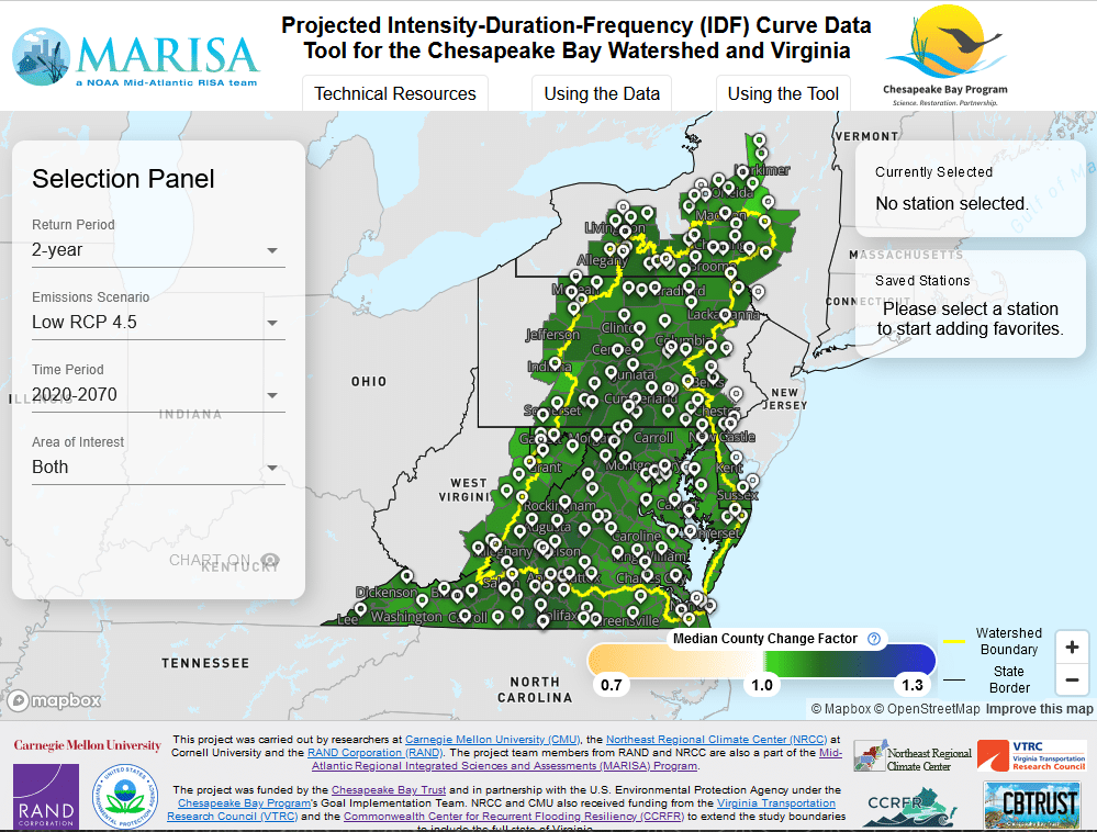
Screenshot of the MARISA Projected IDF curve tool interface. https://midatlantic-idf.rcc-acis.org
To help managers walk through steps to assess how changing conditions may impact their utility and to evaluate potential strategies for mitigating or adapting to these changes, there are decision support tools and technical assistance available through the U.S. Environmental Protection Agency’s (EPA) Creating Resilient Water Utilities (CRWU) initiative. One resource they have developed for smaller utilities that are taking the first steps towards adapting to climate change is called the Resilient Strategies Guide, which is a “web-based introduction to possible future climate conditions and adaptation options used by the Sector.” A more comprehensive climate risk assessment tool for utilities of any size is Climate Resilience Evaluation and Awareness Tool (CREAT), which “compares the benefits of adapting to climate change with the investment required to implement plans.” In addition to holding webinars and trainings on these topics, EPA launched a direct technical assistance effort in 2022 that involves small cohorts of utilities working through CREAT together, with support and guidance provided by EPA and partners. The EPA CRWU website also posts potential funding sources for supporting utilities’ adaptation efforts, which can be accessed here.
Another resource that discusses these challenges is a recent report from the Water Utility Climate Alliance (WUCA) titled Scaling and Application of Climate Projections to Stormwater and Wastewater Resilience Planning. The report calls out best practices and barriers associated with the use, scaling, and direct application of climate projections, with an understanding of the likelihood of future extreme precipitation.
A recent webinar series also addressed many of these issues around climate adaptation for the water sector; the webinar recordings can be viewed by following the links on this page:
Overwhelmed? The New England Environmental Finance Center at the University of Southern Maine prepared a resource in 2022 that provides an overview of many of the tools and resources that are available on the topic of climate adaptation and resilience: Tools for Utility Risk and Resilience Planning: A Guided Inventory.
“There is no consistent federal guidance or regulatory mandates that require utilities to use forward-looking climate modeling and information in their planning. As a result, each agency typically uses their own methods to prepare for future risk, based on their own analyses and available climate science, and their own leadership directives.”
– 2022 Water Utility Climate Alliance report: Climate Projections for Stormwater and Wastewater Resilience Planning
Links
NOAA Atlas 14 – Precip Frequency Data
EPA’s Resilient Strategies Guide for Water Utilities
Climate Resilience Evaluation and Awareness Tool (CREAT)
Water Utility Climate Alliance
Webinar: Showcasing Leading Practices in Climate Adaptation
EFCN’s Tools for Risk and Resilience Planning: A guided inventory