
Movie buffs likely remember the classic film “The Third Man” and its climactic final chase scene set in the wastewater collection system (aka sewers) of post-war Vienna, Austria. The protagonist Holly Martins (Joseph Cotton) races through the dark and shadowy tunnels under the city in chase of his former friend Harry Lime (Orson Welles), who illegally sold Penicillin on the black market and faked his death. Harry finally meets his end in the collection system at the hands of his former friend, after a dramatic chase made more intense by confusing corridors, shadows, and false ends.
They could have used some maps.

Figure 1: Vienna wastewater collection system, the setting for the final scene in the film classic “The Third Man” (source: wien.at)
Like Holly Martins and Harry Lime, wastewater collection system managers can also benefit from maps, but for much more practical purposes. Today’s software supports Geographic Information Systems (GIS) that allows users to explore interactive maps, create paper maps, store data, and analyze information on systems as part of asset management.
A prior post on the EFCN blog highlighted strategies for starting to use GIS tools in managing small systems. Tools such as Google Earth, ArcGIS, and QGIS can all help managers to analyze existing system conditions, plan for future upgrades, and identify distances between components or assets in proximity to rights-of-way. Using the least complex tool to meet management needs is often the best strategy for small systems. Several key questions are important to ask when scoping GIS options:
- What information do I need from GIS and digital maps?
- How much information or data do I have for my system, and what data would I like to have?
- Are there funds available to purchase software?
- Who in my organization has experience with GIS and who will use GIS or the map products?
- Do I need GIS that can support field operations?
Wastewater managers can especially benefit from GIS for numerous important tasks that support operations and maintenance. Through asset management, managers collect information on assets in a system such as location, age, condition, and capacity. When stored digitally with information that includes latitude and longitude, they can be uploaded to a GIS database that allows users to explore interactive maps and examine the attributes of system assets located in the asset inventory. GIS can help managers with all of these tasks because the data is stored as tables, making GIS flexible. Within a GIS map project, the same data can be explored as either a map or a table and both can be viewed and exported (Figure 2).
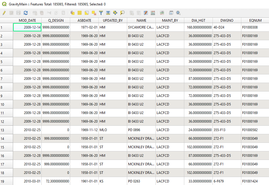
Figure 2: An example of an attribute table in GIS. Each row represents a different asset in the system. Each column represents an attribute associated with that asset (Source: EFC at Sacramento State)
While small wastewater systems likely face many of the same challenges in getting started with GIS as small drinking water systems, there are also unique challenges. Many wastewater systems in North America, even those in medium-sized cities, may not have full maps of their collection system service territories or know where assets are located. Managers of wastewater collection systems that were built decades ago may not have up-to-date maps of pipe locations, or even the extent of the collection system area. In addition, collection systems have many types of unique assets that are all buried underground, including pumps and valves.
Developing a wastewater master plan is an important step toward improved system management. GIS and mapping should be critical parts of a master plan. As a first step in master planning, surface and subsurface assets in a system are inventoried based on visual inspections, video inspections, and information from historic documents like as-built drawings. The inventory includes attributes of location, size, and condition, which can then be converted to maps. Portable GIS devices or even mobile phones can help in collecting spatial data and easily creating a digital database. ESRI’s ArcGIS allows for storing information in the cloud and managing data transfer from field inspections.
Like other water sectors, GIS is becoming a critical tool for managers in small wastewater systems. Building GIS capacity through direct employee hires or by working with external partners can take years, but yields significant benefits for important planning applications such as asset management.