
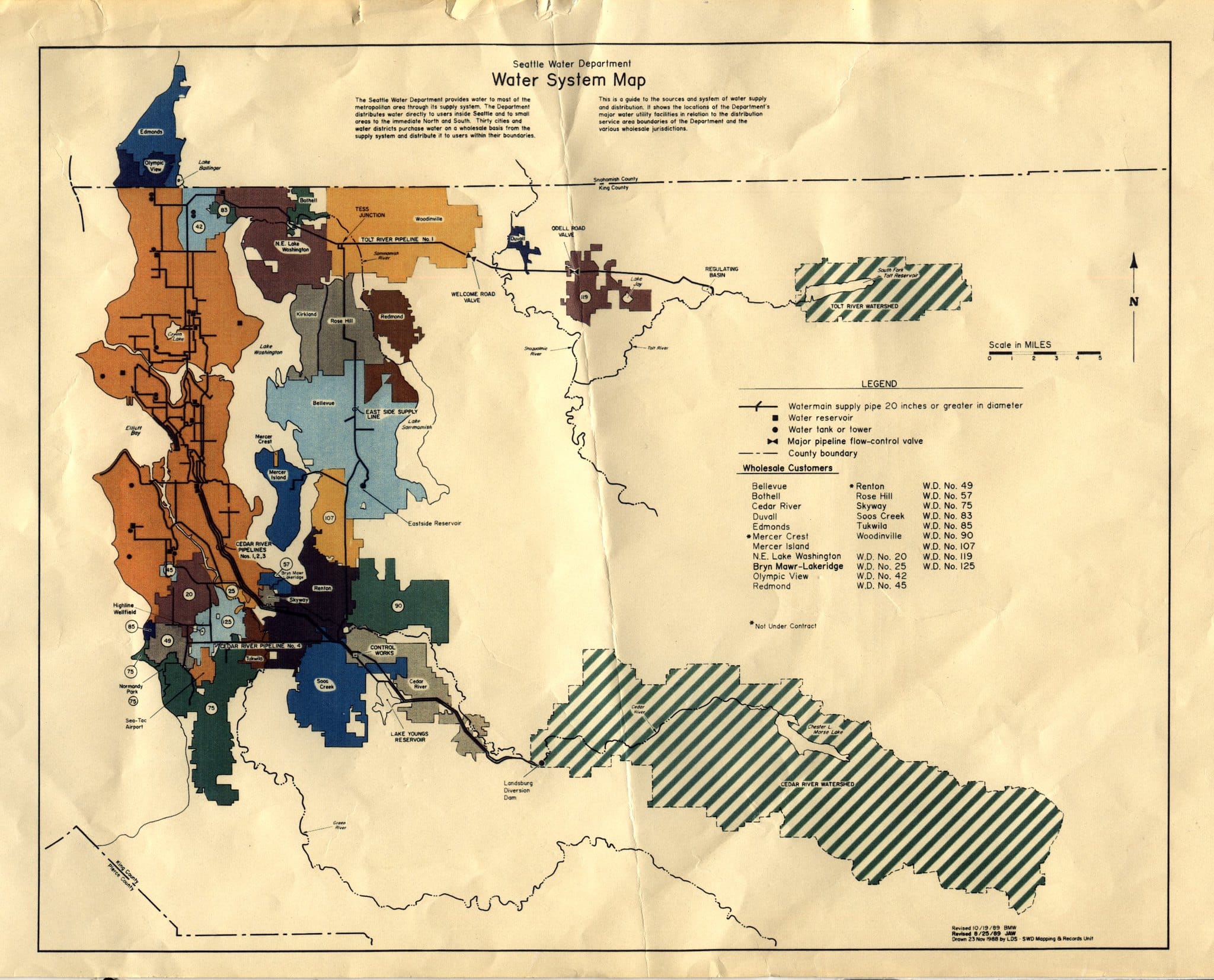
Seattle water system map. Credit: Seattle Municipal Archives
Open any old file of dusty planning documents for a water system, and there will likely be renderings or photographs of paper maps that provide the layout of system components. The information shown on these maps is important to water systems planning, but traditional maps lack the ability to link other important water system information to the data shown on those maps.
Geographic information systems (GIS) offer water system managers tools for mapping and data analysis that can support improved water planning. With GIS software, managers can store and analyze data that includes spatial information. The use of these tools creates powerful opportunities to organize and analyze water management information, including:
- Creating a database of water system assets that includes attributes for each asset such as capacity, size, and age
- Evaluating distances, topography changes, and other infrastructure located near assets or within rights-of-way
- Examining water utility operations
- Linking GIS with other software focused on the water sector such as EPANET or SWMM
- Managing field operations such as inspections and inventories
- Assessing surface and groundwater water resources
- Developing rate studies
GIS can help managers with all of these tasks because the data is stored as tables, making GIS flexible. Within a GIS map project, the same data can be explored as either a map or a table and both can be viewed and exported (Figure 1). The GIS software allows users to dynamically explore the map and view the data in many ways, including as a table of attributes. The underlying data is stored by the GIS software as a series of files.
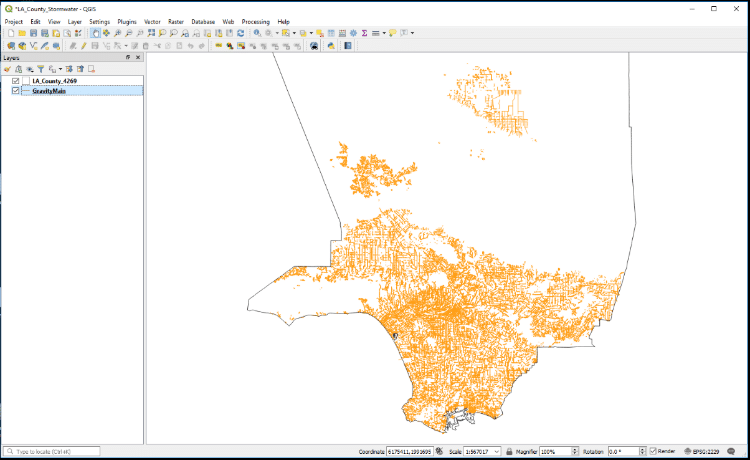
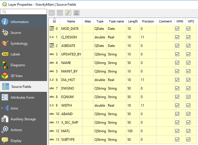
Figures 1 and 2: Data in GIS software can be viewed or explored as either a dynamic map (top screenshot) or table with attributes (bottom sreenshot). Source: EFC at Sacramento State
While GIS provides many opportunities for improving water management and operations, smaller water systems may find it challenging to build GIS capacity. Understanding some basics about GIS software can help a small water system build capacity over time to use GIS. Some commonly-used GIS tools require expensive licenses and all GIS require some level of expertise to understand terminology and applications. Many GIS tools are desktop software applications that store information in a computer, but web-enabled GIS tools that store data in the cloud are increasingly popular. For most small water systems exploring potential GIS tools to support planning and operations, the available funding and expertise will drive initial decisions.
For small water systems, a key strategy is to determine the least complex tool that meets the organization’s needs. When evaluating potential tools, ask:
- What information do I need from GIS and digital maps?
- How much information or data do I have for my water system, and what data would I like to have?
- Are there funds available to purchase software?
- Who in my organization has experience with GIS and who will use GIS or the map products?
- Do I need GIS that can support field operations?
Answering these questions can help choose between GIS options. Several software products are available that support water planning and operations, including:
- Google Earth—A free, open-source application that can be used to develop water system maps and evaluate spatial distances
- ArcGIS—A set of software tools developed by ESRI, a key industry provider. ArcGIS offers free software with limited mapping capacity, licensed software for desktop or network applications, and web-based tools for dynamic maps and field operations. ESRI has also developed a schema for storing and using water utility data.
- QGIS—Free, open-source GIS software for basic and advanced mapping applications and spatial analysis. QGIS was developed by a community of researchers and practitioners over many years. Several plug-in tools are available with water utility management applications.
Each of these GIS support applications of varying scope and complexity (Table 1).
Table 1: Comparing the capability of available GIS software. Source: EFC at Sacramento State
| Capability | Software | ||
| Google Earth | Esri ArcGIS | QGIS | |
| Mapping | Yes | Yes | Yes |
| Spatial Analysis | Limited | Yes, integrated | Yes, integrated or plug-ins |
| Cost | Free/Paid | Paid | Free |
| File and Database Support | Limited | Broad, easy to upload, can be hard to manipulate; ESRI Geodatabases | Broad (except for ESRI geodatabases), harder to upload, can be simpler to manipulate; PostgreSQL |
| Online mapping | Support through Google Maps or 3rd party apps | Support through Esri Online | Support through QGIS Cloud |
| Integrated water utility analysis packages | No | Available packages (field operations, data management) | Not directly designed or integrated |
In deciding among software options and determining the level of commitment for future use of GIS in water system planning, managers can outline a phased approach. It may be easiest to use simple, free tools to begin. This approach allows managers and staff to understand GIS and its uses with a minimum of investment. Once you’ve explored the possibilities, you can demonstrate the value of carving out funding by showing how mapping capabilities can enhance planning, identify efficiencies, and even generate cost savings. Alternatively, for water departments within municipalities, other departments may have existing GIS analysts that can be leveraged.
Water managers in small water systems will increasingly find digital maps a critical tool for planning and communication. Building GIS capacity through direct employee hires or by working with external partners can take years, but yield significant benefits for important planning applications such as asset management.