

The EPA’s 2011 Report to Congress on the Drinking Water Infrastructure Needs Survey and Assessment, which estimated infrastructure capital needs of $384.2 billion over the next 20 years, includes a short line that has stuck with me all summer: “It is difficult to predict future needs.” [1]
Predicting the future in any context is difficult—if not impossible—and state agencies attempting to estimate statewide water/wastewater infrastructure needs must wrestle with some rather unique challenges. One of the challenges is a lack of consistent, long-term capital planning among water systems across the state. Water systems that do not practice asset management planning or have Capital Improvement Plans (CIPs) cannot predict the level of infrastructure investment they need in order to operate beyond the short lifetimes of their existing infrastructure assets.
This blog post provides a brief summary of how policy-makers in Ohio, West Virginia, and Kentucky have addressed this issue by incorporating water system capital planning into the application requirements for water infrastructure funding programs. In some cases, this approach has enabled the development of sophisticated systems for tracking infrastructure needs at the local and state levels. No solution is perfect, but it is clear that taking steps to encourage even basic planning across all water systems can improve financial, environmental, and public health outcomes.
A Buckeye’s View

The Ohio Public Works Commission (OPWC) administers several funding programs intended to help local governments make improvements to public infrastructure. As part of its lending process, the OPWC requires every applicant and current borrower to submit a Capital Improvements Report (CIR) and update it annually until the end of the loan term. The CIR is highly standardized and must contain an inventory of all existing infrastructure assets and their condition, as well as a 5-year CIP, and 2-year Maintenance of Effort report.
The CIR’s inventory component is maintained locally but must be made available to OPWC officials upon request. It covers all infrastructure that is eligible for funding, including—but not limited to—roads, bridges, culverts, and water/wastewater systems. The inventory lists replacement and repair costs, physical conditions, and Financial Condition Ratings (FCRs) for each asset.
The 5-year CIP lists all planned infrastructure projects along with information about cost, funding status, and the grant/loan programs being pursued (even those not administered by OPWC). The final component, the Maintenance of Effort report, provides a summary of infrastructure projects completed in the last two years. This report identifies all projects by funding source and should demonstrate that a community is following its CIP.
Public Works Integrating Committees use the submitted CIRs to prioritize capital projects in their district. After a draft district-level prioritization list has been published, local representatives may appeal the rankings through formal requests. Once finalized, the rankings are used to inform the distribution of funds to specific projects in each of the state’s 19 districts.
In effect, the CIR requirement has made formal asset management, capital planning, and implementation monitoring a prerequisite for access to OPWC funding. It requires communities to demonstrate commitment to long-term planning and promotes a regional view through the district prioritization process. It is still difficult to predict future needs, but the work required to complete a CIR can help reduce surprises and increase readiness for the water systems that complete them.
High-Level Planning in the Mountain State
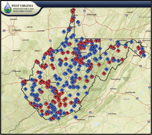 The West Virginia Infrastructure and Jobs Development Council (WVIJDC) is responsible for evaluating funding requests from sponsors of water, sewer, and economic development projects across the state. Project proposals are submitted through an online system and require approval by the Council in order to seek funding from the West Virginia Infrastructure Fund. Since 2011, the WVIJDC has partnered with the West Virginia Water Development Authority to implement a statewide Geographic Information System (GIS) with the following goals:
- Establish a database for existing water and sewer facilities, general locations, and service areas (at least for those systems that have applied for funding);
- Provide a means to continually update the database as new facilities are proposed and constructed;
- Provide an electronic tracking mechanism for funding applications and project status; and,
- Provide the Council with situational awareness to support its decision-making process.
The data captured in the GIS is also used to conduct a comprehensive inventory and assessment of current and future needs for water/wastewater infrastructure once every three years. In the statewide assessment report, ‘current needs’ are defined as water/sewer projects that the WVIJDC has either approved for funding or preliminarily approved as being technically feasible. ‘Future needs’ are calculated using the GIS to estimate the total funding required to provide all of the State’s residents with public water/sewer service.
Through the GIS, West Virginia has effectively created a state-level CIP that is directly tied to project locations. Such ‘high-level planning’ enables officials to consider new proposals, monitor active projects, and make funding decisions within the context of known regional and statewide needs. In this case, simply gathering the relevant information and presenting it spatially may greatly contribute to a more informed view of the future.
Blue Lines below Bluegrass
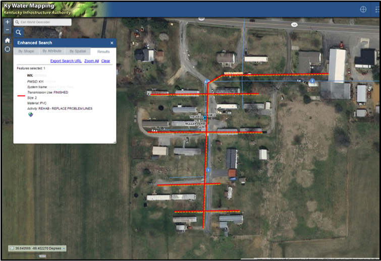 The Kentucky Infrastructure Authority gathers, manages, and analyzes data on water and wastewater systems through a centralized portal called the Water Resource Information System (WRIS). The portal combines information from multiple sources—including the US Census and at least eight state-level agencies—into a single geodatabase that is used to inform a variety of water resource and infrastructure planning activities. Data within the WRIS is detailed enough to identify the location of individual water lines and other system assets. For example, this screenshot shows the location of replacement water lines installed by a private water system to mitigate leaks and improve service for trailer park residents.
Infrastructure needs and project profiles in the WRIS are collected through a ‘bottom-up’ approach facilitated by Area Water Management Councils (AWMCs) operating within each of the State’s Area Development Districts (ADDs). Project profiles are required for application to SRF and other funding programs and may be either uploaded directly to the WRIS by individual systems or collected during annual system visits by ADD representatives. AWMCs meet quarterly and function as the long-term planning entities for the systems in their district. Toward that end, each ADD regularly aggregates project profiles from its district and assigns a regional priority ranking based on a combination of local rankings and other criteria defined at the ADD level.
In addition to serving as a central repository for system and project data, the WRIS is used to produce reports on total statewide water/wastewater infrastructure needs at least once every three years. The reports are organized by ADD and provide a list of all proposed projects along with information regarding timing, funding status, and total project cost.
Like the other states discussed in this post, Kentucky has sought to foster an asset management and capital planning culture by incorporating relevant requirements into the funding application process. KIA’s mapping system helps state officials, water system operators, and members of the public engage with the infrastructure planning process, and even explore alternative solutions for individual needs.
Dealing with Difficulty
To be sure, there are many ways to improve predictions of future infrastructure needs. Incentivizing—or requiring—local capital planning for applications to state-level funding programs is one viable approach. This program-design strategy yields benefits that extend well beyond improvements to the State’s ability to assess infrastructure needs and/or determine an appropriate distribution of limited funds. Importantly, it guides long-term infrastructure capital planning at the local level, thereby helping water system managers and local government officials predict, understand, and plan for their own future.
[1] See Appendix D, Page 59.